Seattle Farm Co-op moves to the Central District

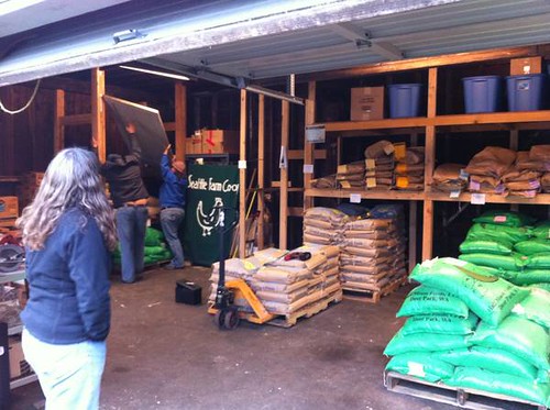
If you are one of the many Capitol Hill and Central District urban farmers, a place to find worms and wholesale feed just got a little closer. Seattle Farm Co-op — a member-owned urban farm co-op — moved-in at 18th and Jackson late last year.

The co-op moved from SODO, where game day crowds made it difficult to operate many days. Now the volunteer-run co-op shares a space with Cascadian Edible Landscapes, Amaranth Urban Farms and a bio fuels co-op. They plan to be open 3-4 days each week, depending on volunteer schedules. A calendar of open hours is posted on the SFC website.

Aside from selling all local and organic feed and supplies for raising chickens, goats and rabbits, the co-op hosts skill sharing classes and a big spring plant start exchange. Past classes have included topics like chicken slaughtering, canning, cheese making and raising goats. The co-op also hopes to develop a tool library for gardening items.

You do not need to be a co-op member in order to buy from SFC, but members get discounts and other deals. It costs $50 to join, and you can also volunteer to offset some of the cost. And they could use all kinds of help, from accounting to website design to people who want to teach skill share classes or help with promotion events. And, of course, they need help staffing the co-op to keep the doors open.

The co-op started in February 2009 in co-founder and board member Amy Stevenson’s back yard in Fremont. But Stevenson does not like to take credit for starting it.

“I just had the idea and sent out an email,” she said. A group got together and determined they needed to pool their resources in order to buy a ton of grain (literally) to get it wholesale. So they did just that and had it delivered to Stevenson’s back yard. They later moved to Georgetown, then to SODO. They arrived in the Central District December 3.

“The co-op supplies the whole city, so we want to stay central,” said Stevenson. When they first started, the majority of members were based north of the ship canal, she said. But now that they have been in south and central Seattle for a while, the geographic disbursement of members has evened out.

The co-op plans to have a grand opening soon, as well as getting a bigger sign. But even with just a tiny sign in the window, they have had many people stop by to support them, said Stevenson.

“It’s been very warming. It feels good,” she said.

Beware Madison — Map marks eight years of Capitol Hill road fatalities

ITO World has created a map marking the spot of every road fatality in the country between 2001 and 2009 (h/t Seattle Transit Blog).

Zooming down to Capitol Hill, Madison stands out as the most dangerous non-freeway in the neighborhood, especially as it goes up to First Hill just north of Seattle U campus. In the eight years included in the map, two people in cars, one person on a motorcycle (could also be a scooter) and one person walking died on the street.


The victims are marked by whether they were in a car, on a motorcycle, on a bike or walking. Each victim square also notes the victim’s age, gender and year of death.

Two people died near or on the University Bridge, two died on 24th Ave E, one died on Union near Harvard, one died on Pine near I-5 and one 89-year-old circus historian died on 17th Ave near Republican.

An area can still be dangerous without any fatalities having occurred, of course. A 12th Ave safety project continues and the city says a traffic signal wouldn’t help the crossing at Boylston and Pine where we’ve covered quite a few car vs. pedestrian incidents. The 12th Ave group meets again next week, by the way:

When: 6pm Wednesday, Dec. 7
Where: Seattle Public Library, Capitol Hill Branch (425 Harvard Ave. E.)

The city recently wrapped up a series of Road Safety Summit forums and is currently working to put the information gathered together and come up with some next steps. The final meeting will be 6 p.m December 12 at City Hall.

Proposed King County redistricting plan moves District 4 off the Hill

Much of Capitol Hill and First Hill currently in King County District 4 will join Districts 2 and 8 if proposed redistricting changes are approved.

Larry Phillips, council member for District 4, said he has loved serving citizens from Capitol Hill.

“As public servants, we go where we are sent,” he said. But he said he will continue standing up for issues important to Capitol Hill residents.

“One of the reasons I was fighting so hard for transit was its critical importance to Capitol Hill,” he said. However, over his time on the council, he is used to the shape of his district changing.

Phillips said he will continue to represent his current district through the end of 2011, including the budget season.

Though District 4 loses parts of First Hill and Capitol Hill in the proposal, it picks up much of North Seattle.

A section of First Hill and Pike/Pine bounded on the north by Denny Way, on the west by 14th Ave and on the south by Yesler will join District 8, which will include West Seattle, west Beacon Hill, SODO, Georgetown, White Center, and parts of Tukwila, Burien and SeaTac.

Capitol Hill north of Denny and west of 15th will join District 2, which includes the rest of Capitol Hill and stretches as far north as Ravenna and south to Renton.

If you have thoughts on the proposed redistricting plan, you can comment online. For more on redistricting, check out the King County redistricting website.

There will be a public hearing on the changes Tuesday night at 6:30 p.m. in the Council Chambers at the King County Courthouse downtown.

Victim identified in Sunday’s 19th Ave house fire

The man killed in a house fire Sunday has been identified as Taj Abdul Randall, 36.

He was in the basement of a house on the SW corner of 19th and Howell when the fire began. Seattle Fire determined the blaze was started by “combustibles stored too close to a baseboard heater.”

SFD was called to the scene around 1:15 p.m October 16. They were able to put the fire out in 10-15 minutes, but Randall died inside.

The Medical Examiner determined Randall’s cause of death was smoke inhalation and thermal burns. It has been ruled an accident.

Seattle Times reports that heating equipment is the cause of many deaths each year:

Fires started by heating equipment cause an average of 560 deaths a year and injure more than 1,600 Americans, the Seattle Fire Department said, citing statistics from the National Fire Protection Association.

Residents should check baseboard heaters often and remove objects — such as newspapers, furniture or blankets — that are on top of or near the heater, the department says.

On Central District News, commenter JR had the following to say about Randall:

Rest in paradise Taj “Tizzy T” Randall. You were a brother to many and you will truly be missed. Praying for your family and everyone who loves you.

New law would allow cities to lower speed limits — Road Safety Summit next week


Red Bike Girl, originally uploaded by glueslabs.

One bill likely to see action in the state legislature this year is HB 1217, which would allow municipalities to bypass red tape when lowering speed limits on non-arterial streets (such as residential streets).

Today, all residential streets in Seattle have speed limits of 25 miles per hour unless a sign designates otherwise. A person struck by a car going 30 miles per hour has a 40 percent chance of dying. When the speed drops to 20 mph, the chance of dying drops to 5 percent. And, of course, collisions are less likely to happen in the first place at slower speeds.

Last year, freshman representative Cindy Ryu of Shoreline was the main sponsor of the bill. The bill has bipartisan support and passed the House unanimously 92-0 before dying in the Senate Transportation Committee. See the postmortem I wrote for Seattle Bike Blog earlier this year.

The bill has come up in the news recently after Mayor Mike McGinn voiced his support for the bill ahead of the city’s Road Safety Summit, scheduled for October 24 in the Bertha Knight Landes Room at City Hall. A time has not yet been announced.


12th Ave Safety Meeting
The Capitol Hill Community Council is inviting interested community members to the next meeting of the committee working on a safety initiative for 12th Ave: 

You are invited to participate in a public meeting regarding traffic safety on 12th Avenue and 12th Avenue East on Wed., Oct. 26, at 6pm at the Capitol Hill Branch of the Seattle Public Library (425 Harvard Ave. E.)   We at the Capitol Hill Community Council have been working in coordination with the Seattle Department of Neighborhoods and Department of Transportation on a Neighborhood Matching Fund project focused on making traveling along 12th safer for all: pedestrians, bicyclists, and motorists.  We recently hired SvR Design to serve as our transportation consultant, and in the months ahead, we will together be preparing a list of recommendations on how to make this street safer.  It is vital that members of our community participate in this process, identifying areas of particular concern and suggestions for how they can be improved.  At the meeting, SvR will be presenting their early observations and gathering your valuable input.

PI: Pine and Bellevue is among Seattle’s worst spots for bike/car collisions

We reported earlier this month that the city has painted a green bike lane in the westbound (downhill) direction of Pine as it crosses Bellevue. The PI reports that the intersection is among the top five spots in the entire city for reported collisions between people riding a bike and people driving.

The green lane was installed after the intersection made the Seattle Department of Transportation’s list of high-collision locations because five collisions were reported there within three years.

“That is a very tangible example of the high-collision bike program at work. We went out and reviewed and created a solution that now will help address this issue,” SDOT’s Rick Sheridan told the P.I. If you have any ideas of how the Pike/Pine corridor could be made safer for bikes, we had a pretty nerdy conversation about it over at Seattle Bike Blog.

Another of the top collision spots is off-Hill, but will likely be familiar to many among the Hill’s bicycling population: The south end of the University Bridge where Eastlake Ave crosses Fuhrman Ave. A popular route to Capitol Hill from the University Bridge bike lane requires people to merge left three lanes in one block in order to turn onto Harvard Ave.

This intersection was also where Bryce Lewis was killed in 2007 after he and another person biking were struck by a dump truck turning onto Fuhrman. The city has since installed a green bike lane at that intersection, as well.

The top spot went to NE 45th St in front of the Dick’s Drive-In in Wallingford.

Here’s a map of the top spots:

B&O Espresso development hit with appeal

An appeal has been filed challenging the city’s recent decision to approve a six-story mixed-use project at 1650 E Olive Way, the current home of B&O Espresso. Though the design is unpopular and will block views, the Department of Planning and Development ruled the project could go forward after years of review and plan revision.

The appeal hearing will be November 2.


In regards to the blocked views, DPD determined that though the blocked views were significant, the same views could be blocked by other projects in the area without environmental review and, therefore, it would be unreasonable to reduce the project in protection of those views:

As part of the consideration, it is understood that future development west of the project site could potentially be permitted without SEPA review (e.g. adding new mechanical equipment and screening on the roof of the brick apartment building to the west) and could cause similar view blockage. It would be unreasonable to reduce this proposal to the extent necessary to maintain fully all of the existing view only to have the view blocked later by projects not subject to view mitigation.

While the impact of the revised proposal is adverse, it is not expected to be significant. No further mitigation based on SEPA public view protection policy is warranted.

The planned project is a 78-unit building with 3,600 square feet of retail and two live-work units at ground floor and underground parking for 52 vehicles. The property developer is John Stoner and the building is designed by Nicholson Kovalchick.

B&O Espresso’s plans are still unknown, but there is likely some time before they have to get out of their current location at E Olive Way and Belmont. No demolition permits have been filed yet.

City will lower 2012 Broadway parking rates between John and Pine

Parking in some parts of the Hill will get a little cheaper next year as the city rolls out adjusted on-street rates. After looking at preliminary parking use data gathered this summer, SDOT is tweaking the on-street rates across the city.

Most rates will remain the same, including Broadway north of John, Pike/Pine, First Hill and 12th Avenue.

However, the section of Broadway between John and Pine saw high enough vacancy that the city is lowering those rates in an attempt to provide relief to the higher occupancy areas in the neighborhood. The city has stated that its goal is to achieve an 80 percent occupancy rate on all blocks so that a space or two is free most of the day. According to the plan, it will cost $0.50 less to park between John and Pine starting in 2012.


Here’s a map of parking occupancy in the neighborhood. The boxed area shows streets where the rates will be lowered to $2.50 per hour.

From SDOT:

•    The highest average occupancy is clustered in the northern sections of Broadway, as well as at the intersection of Broadway and Pine Street. Based on peak utilization patterns, the 12th Avenue Area north of Pine Street could also be considered high demand, especially during weekend and evening peaks.

•    Capitol Hill will benefit from the introduction of a tiered rates parking management strategy; this approach uses the data to determine the boundaries and pricing, in contrast to a general district approach.

•    It is anticipated that lower rates will increase utilization of the lower occupancy areas and provide relief to the higher demand areas by encouraging people to park south of E Olive Way / E John Street.

Capitol Hill Recommendation_v4

New green bike lane at Pine and Bellevue, giant I-5 symbol on Olive

The city recently painted a green bike lane through the intersection of Pine and Bellevue in an attempt to increase the visibility of people biking downhill.

The city only installed the green paint in the westbound (downhill) lane, and a new sign facing traffic facing southbound on Bellevue reminds people to yield to people biking in the lane before making a right turn onto Pine.

The green paint is meant to remind people turning to look out for people in the bike lane. Someone making a turn in front of someone biking is one of the most common types of traffic incidents involving people riding bikes.

In other roadway paint news, Hello Seattle posted this photo of a new in-lane I-5 symbol on E Olive Way that lets people know which lane goes to the big highway thingy.

Image from Hello Seattle

Before somebody else gets hurt, where are the Hill’s biggest bike safety hazards?

After Brian Fairbrother’s bicycle crash on Fairview Ave N late last month, the city initially denied that they received complaints about the danger the staircase could pose to someone riding a bike. Now, the SunBreak reports that a 2008 email chain between a concerned citizen and the Parks Department and SDOT warned of the hazard in eerie detail:

As the Parks Department had put up a sign soliciting feedback, [Michael] Hoffman responded with an alarming prescience:

It was nice ride in general but there were a few places that were a bit confusing or even dangerous for an unfamiliar rider. I’m not sure if the loop is considered finished yet but I thought these comments might be helpful. […] There is a bit on the east side where the trail seems to go down a lot of steps and then back up. It is not apparent until you are near the steps that they are actually steps rather than a ramp. I think this is dangerous currently. I would strongly recommend some warning signs here. If cyclists are meant to instead travel on the nearby road against the traffic flow, the trail needs signage and road markings to indicate this.

So does this show that the city needs to be more responsive to citizen comments and hazard warnings? Maybe. The city told the SunBreak that this note was “one of many comments received during that process.” A quick look at BikeWise.org, a website that tracks citizen-reported hazards around the city, shows zero hazards reported at that spot

Yet, once it became clear where his crash occurred, many people (myself included) recognized the location and were familiar with the hazard posed by the stairs. Would the city have acted more quickly if more of us had been persistent about the need to fix the problem? Maybe.

For many types of hazards, the city is very responsive to citizen reports. Issues like potholes, some sidewalk issues and dangerous sewer grates are often fixed in a reasonable time period. Perhaps a more useful question for the rest of us at this moment is: What can we all do to help prevent something like this happening elsewhere?

Asherah posted the following sound advice at Seattle Bike Blog:

I read the comments on here a few days ago, and three separate people said they’d fallen at that same spot, and that it wasn’t well marked or that there used to be a sign there and then wasn’t. Then I read in the Times that the city had received no complaints about it…..No sense blaming or second-guessing now, but PLEASE bikers when you find a particularly unsafe, unmarked spot in a Seattle bike trail or lane, let the police and city know.

Here’s how you can report hazards (bookmark and/or add to your phone books):

  • Report the incident to SDOT’s online Street Maintenance Request Form. Even if it doesn’t seem to fit with their options, just choose whatever fits best (SDOT, updating that form to allow for bike-related hazards would be awesome)
  • Call SDOT at 206-684-ROAD
  • Report the hazard at BikeWise.org. Not only will your hazard report be public, but the site attempts to forward your concerns to relevant departments in the city, county and state. Pretty cool!
  • If you have a smart phone, download the slightly buggy but also pretty cool BikeWise app (search your app store for “bikewise”). The app lets you start a hazard report where you are, marking the location and type of hazard. It then emails you your started report so you can complete and submit it at the BikeWise website. Maybe it’s a little roundabout, but it’s still pretty cool.

Where are the persistent hazards you see on the Hill? I have one: There are bike-wheel-grabbing sewer grates on 16th Ave E near Denny.

Report your hazard to the city and note it in the comments below so the rest of us are aware. Telling city planners about dangers is part of the battle. But making community attention — and action — part of the solution may be, in the end, just as important. We’ll never get to 100% safety. But, yeah, we can do better.