


Poll: Where should the streetcar run?
The Seattle Department of Transportation has released a set of maps documenting the proposed alignment alternatives for the streetcar that will connect the Capitol Hill light rail station with Union Station on the edge of the International District.
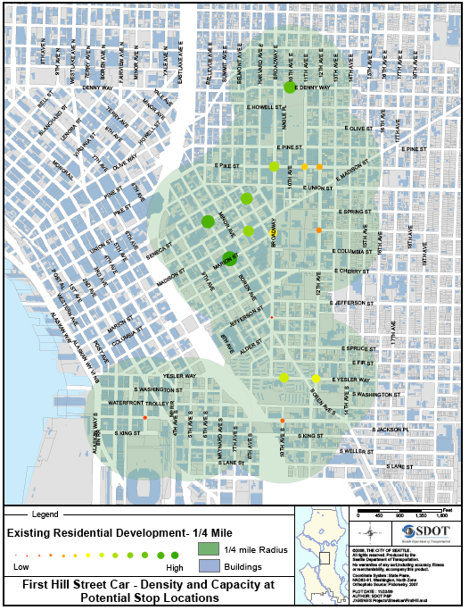
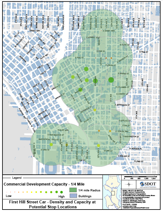
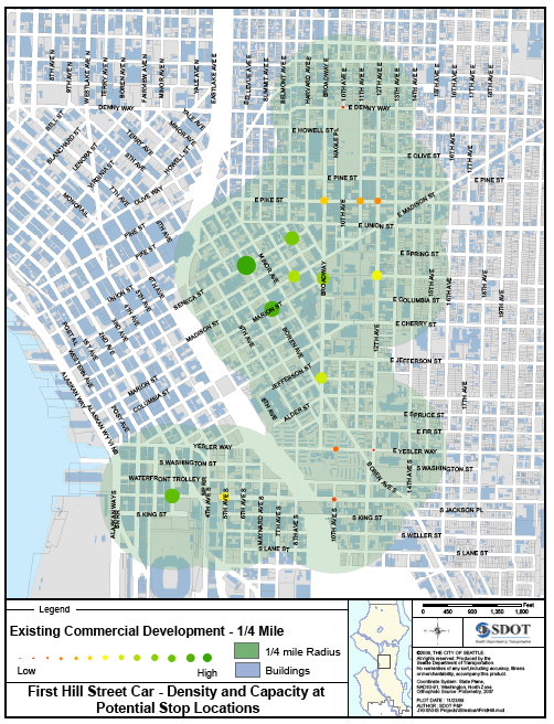
UPDATE: Also check out the set of maps showing analysis of the area’s commercial and residential density and the planned future capacity. We’ve included images from those maps at the end of the post.
The maps solidify the discussions around the three potential options — the Boren route, the Broadway route and a 12th Ave/Broadway ‘couplet’ that would encircle a big chunk of southern Capitol Hill into the Central District. We’ll learn more about how the city is positioning these alternatives in Tuesday night’s community meeting at Seattle Central. More info on that, below.
In addition to the maps provided by SDOT, we’ve included Google Maps of the three routes at the bottom of this post. Examining the maps reveals some notes of interest. For one, all routes have become ‘loop’ routes with the addition of 11th Ave segments to the alternatives.
Also, in both the Boren and the 12th/Broadway couplet routes, the central Pike/Pine stops would be on E. Pike — one at Pike and 11th, the other at Pike and Broadway (dropping riders off in front of a Shell service station, ironically). The Broadway route would also include a stop at Pike and Broadway but it’s 11th stop would be at the corner with Madison, across the street from Seattle University and near the future development of the lot that currently is home to the Undrearms Apartments .
For a perspective on the alignment maps from the Central District, check out CDNews coverage here . Their takeaway is 12th Ave looks better and better: “It puts more people within access to a stop, gives good service to Swedish and Seattle U, and is the shortest, which should save money and shorten travel times from any given point.”
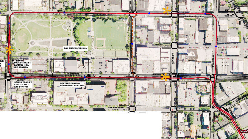
 Cal Anderson section of the 12th Ave alternative (Figure 6 PDF)
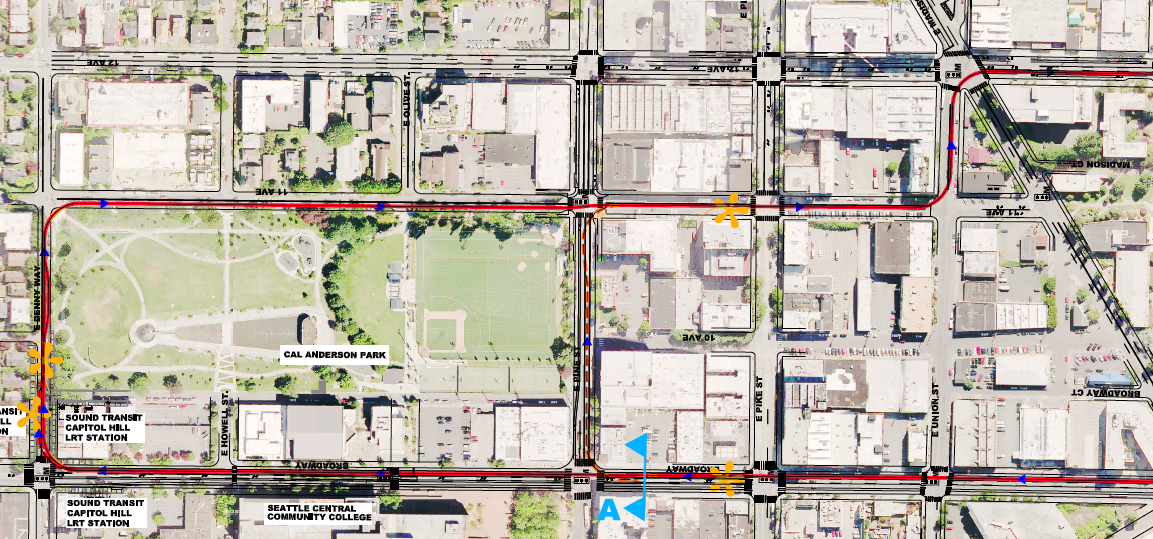
 Boren route alternative’s Capitol Hill components (Figure 5 PDF)
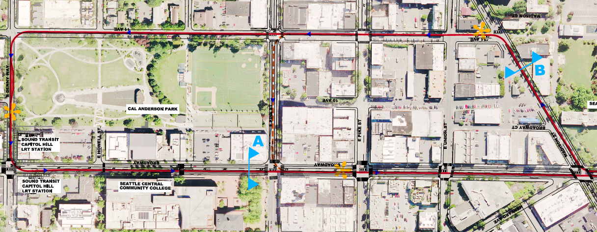 The Broadway route north of Madison (Figure 4 PDF)
 We’ll post images shortly but
Alignment Alternatives
- Alignment Figure 1
- Alignment Figure 2
- Alignment Figure 3
- Alignment Figure 4
- Alignment Figure 5
- Alignment Figure 6
- Conceptual Sections
- 2nd Ave S Concept Section
- 5th Ave S Concept Section
- 11th Ave Concept Section
- Capitol Hill Station Concept Section
- Yesler Terrace Concept Section
Streetcar Bicyle Integration
- Streetcar-bike best practices 1
- Streetcar-bike best practices 2
Density + Capacity with Potential Stop Locations
- Commercial Density
- Residential Density
- Commercial Development Capacity
- Residential Development Capacity
Also, here’s a collection of CHS coverage of the streetcar process and information about Tuesday night’s community meeting:
- The Case for a 12th Ave Streetcar
- Seattle Transit Blog doesn’t like 12th Ave streetcar route
- Putting more First Hill in the First Hill-Capitol Hill streetcar
- Streetcar 2013: City Council moves $120 million plan forward
- Will the streetcar make a Stranger stop? 11th Ave option reportedly enters mix
Tuesday night’s meeting will be the first of three sessions organized by the Seattle Department of Transportation to discuss the streetcar project with the community.
Tuesday, December 15 6:00 PM-8:00PM
Seattle Central Community College (1701 Broadway)Wednesday, December 16 6:00 PM-8:00PM
Yesler Community Center (917 E. Yesler Way)Thursday, December 17 6:00 PM-8:00PM
Union Station (401 S. Jackson Street)
Thanks to Scott at Central District News for sharing his fast Google Maps work with us.
The “Two-way Broadway” option (4.38 miles long):
“Broadway/12th Couplet” includes southbound service on 12th Avenue (4.26 miles long):
First Hill Boren route (4.89 miles long)
Here are the commercial and residential density maps and their future capacity counterparts.

However, to run the streetcar down Denny between 11th and Broadway, the City will likely need to either (i) make that stretch of Denny one-way; or (ii) eliminate parking on one or both sides of that section of Denny to allow enough room for the streetcar and two-way traffic.
I’m also interested to hear how realistic it is to add tracks to Madison as would be necessary in the current Broadway alternative. We all know that Madison had streetcars in the past but it’s a much different street now.
If you dig into the documents, you’ll find that they do indeed call for Denny to be restricted to Westbound traffic. I question the need for any cars through Denny. Why not turn it into a pedestrian/streetcar plaza right outside the light rail entrance?
Good point, jseattle. It seems to me the alignments using Union St would be more effective than Madison. Union is relatively free of traffic and has a lot of redevelopment potential. It is unfortunately a bit of a sketchy street right now.
At first my reaction was pretty negative to this 11th ave idea because it just seems to make more sense to do a 2-way broadway alignment, but on further examination this wouldn’t be so terrible. The 2-block difference between 11th and broadway is not as much of a deal as the 3 blocks between 12th and broadway, partly because it doesn’t have the 11th-to-12th hill to deal with, and partly because it is restricted to one end of the line (assuming 12th ave alignment goes away). Since the whole 11th ave stretch is close to the light rail station anyway, it isn’t as big a deal having the 2 directions separated. I hope that makes sense. Anyway, it doesn’t make much sense to me, but also not the end of the world.
So it appears to me that the biggest story here is that the streetcar will not extend all the way down Broadway to Aloha. When did this happen? The Aloha extension was always a part of the plan. Is it not anymore?
Yeah I think that I’m in the same boat. I have concerns about it but it seams like SDOT has valid reasons to do this, especially if it can speed up travel time from First Hill to the station.
No it was always contingent on more funds or the current project coming in on budget. With new federal funds for streetcar projects available this the segment to Aloha could possibly funded with federal money.
I understand the funding source and the promise to First Hill. So go ahead and keep that promise. Now tell me who needs to kick in money to make sure that the streetcar serves the present and growing Broadway population north of John & Olive. The streetcar should serve all of Broadway and give north Broadway a link to light rail and beyond. Is this streetcar going to be like Link service just to Tukwila or SLUT service just to Westlake? Hey guys, find the money and complete the line to Roy or Aloha!
Ethan informed me that the Aloha extension would cost around $25 – 35 million. I doubt there is any hope for it in the first construction phase because seeing as they are already trying to expedite the project, a don’t think they want to wait for an additional funding source.
That said, when discussing this the other day the idea came up to add this into the (assumed) Transit package that McGinn says he will propose in 2012. Similar to ST2, perhaps a little extra money can be thrown our way when we vote on Ballard to West Seattle. Maybe for $100 million we could even push it up to Roanoke. Granted it isn’t the most dense part of the city but their sure is a lot of wealth that could be spent in the southern business districts, and car-free!
On the 11th alignment: I do think that exclusive ROW should be pushed for if its really going to be worthwhile. The street is wide enough and the traffic low enough that it seems pretty reasonable to have a one-way car lane/bike path and an exclusive streetcar lane. I think the potential for creating a really great urban street through Pike/Pine, next to the Park, and at the Denny/10th section is very exciting. I’m envisioning things similar to the streetcar through PSU…
The “2 way Broadway” option makes the most sense to me. I’m not sure how many people want to walk uphill between Broadway and 12th South of Madison to transfer directions. It’s so much simpler to catch both directions of the the street car on the same street.
Also,why aren’t they having the north terminus circle around the block surrounded by Nagle Place, E Howell St, John St, and Broadway? That’s the block they’ve already obliterated for the light rail tunnel station and the obvious point where everyone can transfer between the two systems. That seems like it would also save money because it minimizes the locations that need to be demolished to install the tracks. Hopefully it could save some of the last available parking on the East side of Cal Anderson.
The First Hill Boren route seems the most convoluted of the 3. There are so many turns in the route that it seems like it will be a completely ineffecient use of riders time. I envision the street car being stuck in traffic a lot on Boren.
Thanks!
seriously, let’s try some straight lines. pick one, any one. just don’t build a useless alignment from day one.
I’m mostly very happy with the efforts to plan for compatibility with bikes in the Broadway and 12th plans. All the plans share some sections on 11th near Cal Anderson and on 12th near Jackson where it looks like cyclists could get squeezed too close to the rail. But it’s nice to see how many bike lanes have been incorporated into the street cross sections diagrams.
The Boren option however creates quite a few more conflicts for cyclists especially on Seneca and Minor, which are now some of the better streets for riding through First Hill. Looking at the street cross sections, cyclists will definitely be squeezed between the rail and parked cars on these streets. Another strike against this option in my opinion.
My concern with the 12th ave option is that it could hinder emergency vehicle response times. Both Broadway and 12th ave are heavily used North and South arterial routes by emergency responder vehicles. The East Precinct Police department and the East Pine Fire Station off of 13th ave make heavy use of the 12th ave corridor.
Keept in on Broadway – Alt 1.
At first I was horrified by the Street Car navigating the three-way intersection of this route, then I considered the potential users and how it would affect future growth. With a wider breadth geography, this option seems to better serve a rapidly expanding Capitol Hill/First Hill while offering minimal impact on traffic. The Broadway option only solves a very small amount of Profanity Hill Woes; hills are a part of life in the city, and we all know the best routes around them, if we have the time. These tracks will not change soon, if ever.
As for the Boren/Minor route, having an arm that stretched into downtown would also be useful, however Boren is not the place to insert permanent transit because it is one of the few streets in Seattle that is a reliable & car-friendly thoroughfare and I can foresee little good in tearing up Minor.
Let’s make something that gives us the most options for future Street Car expansion, present needs, and get past doing what’s simplest.
Streetcar route maps released with community meeting a day away